Astronomers know that the following set of well defined atmospheric conditions makes for excellent astronomical observations: cloud cover should be minimal, the frequency of unfavourable weather conditions such as cyclonic storms and thunderstorms should be very low, the air above the observatory site should be dry, the change in air temperature during the night should be minimal and atmospheric transparency should be high.
Relevant surface layer meteorological variables for site characterization are air temperature (T), barometric pressure (P), relative humidity (RH) and wind velocity (V, broken down into speed and direction). Other parameters, such as sky transparency and photometric conditions, are taken into account to define the astronomical suitability (see Ardeberg 1983; Murdin 1985; Mahoney et al. 1998).
Large changes in air temperature during the night make it more difficult to minimize dome and mirror thermal perturbations, known as dome and mirror seeing. The surface layer, due to convection (calculated from ground-air temperature differences), is also expected to be less significant when the temperature remains stable during the night;
At the ORM, the analysis of temporal behaviour of night-time seeing shows no dependence of seeing on time. No variation of seeing has been detected that could be associated with the beginning or the end of the night (Muñoz-Tuñón et al. 1997), supporting the negligible value of the surface layer seeing as reported by Vernin & Muñoz-Tuñón (1994);
Relative humidity at ground level provides a useful value in determining conditions in which astronomical observations can be made. Humidity higher than, say, 90% (Murdin 1985) makes observing unfeasible. The optical surfaces become wet and can be damaged. The percentage of hours with humidity less than 90% sets an upper limit on observable time. However, it is important to mention that relative humidity is a local measurement which relates poorly to the water vapour column at the site; therefore, relative humidity by itself cannot determine the suitability of a site for infrared observations;
Wind speed and direction also constrain the operating of telescopes. While wind speed of, say, 15 m s-1 may be taken as a typical maximum safe operating value (Murdin 1985), the maximum operational wind speed will also depend on the angle between the orientation of the dome slit and the oncoming wind;
The overall climate of the Canary Islands is determined by the trade winds, which are 90% prevalent in the summer and 50% prevalent in the winter (see Font Tullot 1956), and which arrive from the NE. The prevailing wind vector veers with height, and at the level of the Observatories, well above the inversion layer, the trades arrive from the NW (although there is a seasonal variation since the Azores anticyclone, which, together with the Canary Current, drives the trade winds, migrates in the north-south direction inaccordance with the change in declination of the the Sun (see Mahoney et al. 1998);
Recently, a correlation has been found between poor image quality and southerly winds at ORM, although these do not reflect typical conditions at the ORM. Further study of this correlation between wind direction and seeing could be of interest for climatology research (Muñoz-Tuñón et al. 1998);
The trade winds in the Canary Islands correspond to a general anticyclonic circulation and provides a mean pressure value (at ORM) higher than that theoretically expected for this altitude. The frequency with which this happens is an indirect indication of high atmospheric stability;
Large temporal gradients in pressure are frequently associated with changes from anticyclonic to frontal weather and possible deterioration in observing conditions (storms, strong winds, clouds, etc.);
While atmospheric extinction is determined by atmospheric transparency, spatial and temporal variations of this variable are related almost entirely to differences in the concentration of suspended particles. Since observatory sites are usually in dry, isolated areas, dust is the most common particle that affects transparency. The quantity of dust in the air depends on the altitude of the observing site and its proximity to a dust source (e.g. deserts) and prevailing wind. Even if an observatory site lies well above the inversion layer, dust can still have an important effect on atmospheric transparency;
For example, in the Canary Islands, when eastern winds occur above the inversion layer, Saharan dust is carried over the islands from the desert interior of North Africa, degrading atmospheric transparency. Most of the time, however, the air reaching the observatory sites of the Canaries has traversed thousands of kilometres of featureless ocean and will accordingly be free from suspended particles. Therefore, with regard to atmospheric transparency, isolated oceanic sites have a decided advantage over continental sites provided that oceanic sites lie above the inversion layer (Guerrero et al. 1998, 2000; Murdin 1985).
| Dome seeing | Mirror seeing | ||
| (
|
(arcsec) | (arcsec) | |
| Mean | 1.72 | 0.19 | 0.77 |
| Max. | 9 | 1.4 | 5.6 |
![\begin{figure}
{\includegraphics[height=6cm,width=7.9cm]{ds1856f4.eps}\includegraphics[height=6cm,width=7.9cm]{ds1856f5.eps} }
\end{figure}](/articles/aas/full/2000/20/ds1856/img7.gif) |
Figure 3: Daily mean variation of temperature. Left: the temperature measured at 1.5 m above ground level at Oukaimeden. Right: the temperature measured at 10.5 above ground level at ORM |
![\begin{figure}
{\includegraphics[height=6cm,width=8cm]{ds1856f10.eps}\includegraphics[height=6cm,width=8cm]{ds1856f11.eps} }
\end{figure}](/articles/aas/full/2000/20/ds1856/img10.gif) |
Figure 6: Cumulative frequency of relative humidity at Oukaimeden (left) and ORM (right). The median value is 40% at Oukaimeden and 31% at ORM |
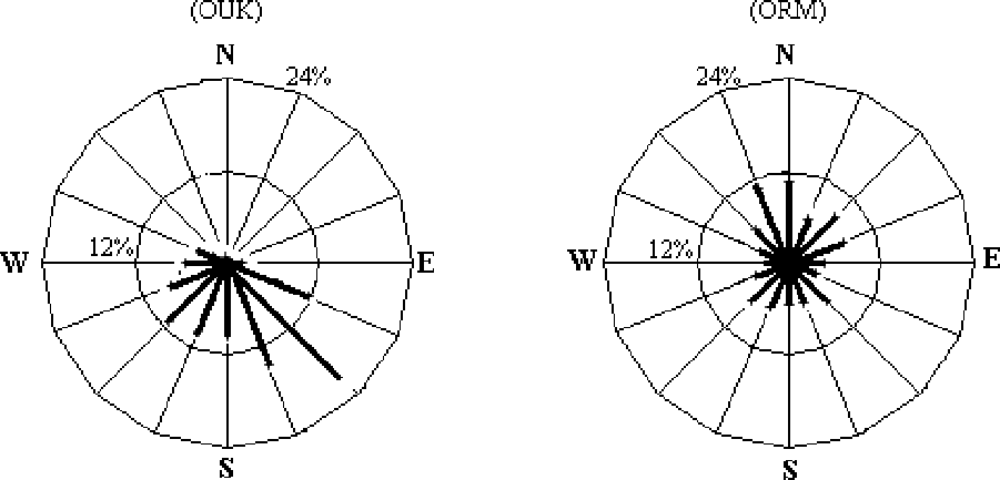 |
Figure 8: Night-time windrose at Oukaimeden (left) and ORM (right). The frequency data is calculated respectively on 4541 hours of measurements at Oukaimeden and over 14748 hours at ORM |
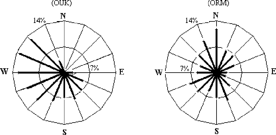 |
Figure 9: Daytime windrose at Oukaimeden (left) and ORM (right). The frequency data presented is calculated respectively on 4650 hours of measurements at Oukaimeden and over 13575 hours at ORM |
![\begin{figure}
{\includegraphics[height=6cm,width=8cm]{ds1856f18.eps}\includegraphics[height=6cm,width=8cm]{ds1856f19.eps} }
\end{figure}](/articles/aas/full/2000/20/ds1856/img15.gif) |
Figure 11: Cumulative frequency of wind velocity at Oukaimeden (left) and ORM (right). The median value is 2.1 m s-1 at Oukaimeden and 2 m s-1 at ORM |
In Figs. 2-11 plots are shown for mean monthly air temperature, daily mean air temperature, monthly temperature difference between two consecutive nights, mean monthly relative humidity, cumulative frequency of relative humidity, daily relative humidity, night-time wind rose, daytime wind rose, mean monthly wind speed and cumulative frequency of windspeed, respectively. In each figure, the left-hand panel corresponds to Oukaimeden (OUK) and the right-hand panel to the Observatorio del Roque de los Muchachos (ORM). The recorded data from 10 UT to 16 UT were used to sample daytime conditions and from 22 UT to 04 UT to study night-time conditions and from 0 UT to 24 UT refer to daily results.
Copyright The European Southern Observatory (ESO)
![\begin{figure}
{\includegraphics[height=6cm,width=8cm]{ds1856f2.eps}\includegraphics[height=6cm,width=8cm]{ds1856f3.eps} }
\end{figure}](/articles/aas/full/2000/20/ds1856/img6.gif)
![\begin{figure}
{\includegraphics[height=6cm,width=8cm]{ds1856f6.eps}\includegraphics[height=6cm,width=8cm]{ds1856f7.eps} }
\end{figure}](/articles/aas/full/2000/20/ds1856/img8.gif)
![\begin{figure}
{\includegraphics[height=6cm,width=8cm]{ds1856f8.eps}\includegraphics[height=6cm,width=8cm]{ds1856f9.eps} }
\end{figure}](/articles/aas/full/2000/20/ds1856/img9.gif)
![\begin{figure}
\par\includegraphics[height=6cm,width=8cm]{ds1856f12.eps}\includegraphics[height=6cm,width=8cm]{ds1856f13.eps}\end{figure}](/articles/aas/full/2000/20/ds1856/img11.gif)
![\begin{figure}
{\includegraphics[height=6cm,width=8cm]{ds1856f16.eps}\includegraphics[height=6cm,width=8cm]{ds1856f17.eps} }
\end{figure}](/articles/aas/full/2000/20/ds1856/img14.gif)