In MAO RAS the position observations of the main Saturnian
satellites were performed on a 26-inch refractor with a focal
length of 10.4 m. The images were obtained on an ST-6-type
CCD during some of the observing sets and photographic plates
during the other sets.
Another name of MAO RAS is Pulkovo observatory. Its coordinates
are: east longitude ![]() , north latitude
, north latitude ![]() , an altitude of 75 m.
, an altitude of 75 m.
We reduced the CCD frames to determine the angular separations between the satellites and the corresponding position angles. If a frame contained more than two satellite images the relative coordinates were computed for each satellite pair and each set of such coordinates constituted a separate measurement consisting of a separation s and position angle p.
The orientation of the CCD frames determined from traces of
the satellites in their diurnal motion. The frame scale follows
from the comparison between the images of star clusters
on the photographic plate and on the CCD frame.
The position angles are determined for the first satellite in each pair (i.e., the one whose number is goes the first). The second number refers to the satellite with respect to which the position angles were determined. Position angle is measured from the North direction in the equatorial reference frame for the epoch of observation. The time is on the UTC scale.
The results have been corrected for
differential refraction. The rms errors ![]() ,
, ![]() of
measured coordinates s, p were inferred from repeatability
of measurements based on a set of CCD observations. Each set
consisted of 4-10 images. The result file contains a total of
15 measurements.
of
measured coordinates s, p were inferred from repeatability
of measurements based on a set of CCD observations. Each set
consisted of 4-10 images. The result file contains a total of
15 measurements.
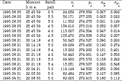
Table 2 gives results of the described CCD observations.
The results of these observations can be found in file
kccdb.dat.
Each line in this file represents a separate measurement and
consists of 12 numbers:
1 - year,
2 - month,
3 - number (dates observ.),
4 - hour,
5 - min,
6 - second (moment observ.),
7 - number of first satellite,
8 - number of second satellite,
9 - angular distance between satellites s (arcsecond),
10 - position angle p (degree),
11 - the rms errors of angular distance between satellites ![]() (arcsecond),
(arcsecond),
12 - the rms errors of position angle ![]() (degree).
(degree).
We now describe the results of photographic observations of the
major Saturnian satellites. We used the plates to measure the
satellite coordinates relative to both the center of the planet and
that of satellite Titan. The measurements yielded relative
coordinates ![]() , where
, where ![]() and
and ![]() - right
ascension and declination, respectively, indices i and
j denote the number of the satellite and that of the body
relative to which the coordinates have been measured,
respectively: j=0 for Saturn and j=6 for Titan. The
coordinates are referred to the equatorial reference frame for the
epoch of observation and have been computed with correction for
differential refraction.
- right
ascension and declination, respectively, indices i and
j denote the number of the satellite and that of the body
relative to which the coordinates have been measured,
respectively: j=0 for Saturn and j=6 for Titan. The
coordinates are referred to the equatorial reference frame for the
epoch of observation and have been computed with correction for
differential refraction.
The center of Saturn's image has been determined by measuring two points of the polar diameter of the planet and two points of the equatorial diameter with rings on the photoplates. The astrometric reduction of the relative coordinates of satellites was carried out by the formulas of "scale-trail" method worked out by [15, Kisselev (1993]).
The results of photographic observations are written in a
separate file kphot.dat. The following format is used. Each line
contains full data for a single measurement of relative satellite
coordinates x, y, represented by a sequence of 10 numbers:
1 - year,
2 - month,
3 - number with part of day (moment of observ.),
4 - conditional number of photographic plates,
5 - satellite number (i),
6 - number of main body (j=0 - planet, j=6 - Titan),
7 - coordinate x (arcsecond),
8 - coordinate y (arcsecond),
9 - rms coordinate x (arcsecond),
10 - rms coordinate y (arcsecond).
The times of photographic observations are in the UTC scale. The measurement errors were computed from the repeatability of measurements based on several exposures taken on the same plate. There were usually 6 - 7 exposures per plate. The file contains a total of 237 lines (measurements) of which 128 are satellite coordinates relative to the planet and 109 are satellite coordinates relative to Titan satellite.
Copyright The European Southern Observatory (ESO)