What are the possible future implementations for this technique?
 |
In order to refine the performances of the model some modifications could be suggested.
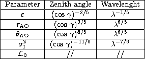
Introducing a zenithal (![]() ) and chromatic (
) and chromatic (![]() )
dependence in the code, one could forecast,
at a precise t0, for a fixed telescope position (x0, y0), the values of all the
parameters coded in the model for each line of sight and
for each spectral band. In Table 2 are reported the zenith angle and the chromatic dependence of the optical turbulence
parameters coded in the model.
The possibility to reconstruct 3D maps of the optical turbulence could be an efficient
tool for site testing. The numerical technique could substitute or complete the data provided from
the often expensive campaigns organized to build a climatologic data base of a particular site.
The model could give a complete
3D description over an extended surface at the same time for different sites using the same tool.
)
dependence in the code, one could forecast,
at a precise t0, for a fixed telescope position (x0, y0), the values of all the
parameters coded in the model for each line of sight and
for each spectral band. In Table 2 are reported the zenith angle and the chromatic dependence of the optical turbulence
parameters coded in the model.
The possibility to reconstruct 3D maps of the optical turbulence could be an efficient
tool for site testing. The numerical technique could substitute or complete the data provided from
the often expensive campaigns organized to build a climatologic data base of a particular site.
The model could give a complete
3D description over an extended surface at the same time for different sites using the same tool.
In the context of flexible
scheduling this technique could give a contribution in the gestion of the observing
modes at a telescope. Particularly favorable conditions could be used for High Angular Resolution
techniques as the Interferometric one and a more modest seeing could justify a Direct Imaging or a
Spectroscopy technique. Moreover, in order to determine the
accuracy of the wavefront sensor and the performances of the adaptive telescope we could forecast
2D maps of the rms residual wavefront error ![]() obtained over an aperture D
for an adaptive optics system achieving perfect tilt
compensation (Fried 1965) and the Strehl ratio for this perfect tilt removal (Chester et al. 1990).
The model could be an useful tool, not only for the gestion of the observing mode but also for
the gestion of the focal instruments placed at the focus of the telescope.
obtained over an aperture D
for an adaptive optics system achieving perfect tilt
compensation (Fried 1965) and the Strehl ratio for this perfect tilt removal (Chester et al. 1990).
The model could be an useful tool, not only for the gestion of the observing mode but also for
the gestion of the focal instruments placed at the focus of the telescope.
A three-dimensional picture of the turbulence provided by Meso-Nh could be used as a more realistic model than the empirical Hufnagel model (Roddier 1981) or the simpler single layer model frequently employed.
Thus knowing the altitude of each layer as an output of our model, it becomes possible to help to implement MCAO (Multiconjugate Adaptive Optics) technique (Tallon 1992).
In this paper we describe the general characteristics of the Meso-Nh model, the parameters coded in the model characterizing the optical turbulence and the applications that this tool could have for site testing, for optimization of the adaptive optics technique and for flexible scheduling. We showed both the potentiality of this technique and the general coherence of the informations that it could provide. We proved the model sensitivity to the orographic effects and we tested the influence of the horizontal resolution on the simulations outputs. The model ability to reproduce a correct spatial distribution of the optical turbulence is supported by a comparison between Scidar measurements and Meso-Nh simulations (Fig. 8).
The challenge for a future implementation of this technique in the astronomy field depends from:
In the following article, we give the results of a systematic statistic analysis taken over 15 nights of the PARSCA93 (Fuchs et al. 1994) campaign (5/1993). Useful informations about the sensitivity and the statistic reliability are provided in this paper.
Acknowledgements
This work is supported by contract (Technical Report UNI-17400-0004) from ESO. The authors are grateful to M. Sarazin for his constant and dedicated presence in this feasibility study. They wish to thank the GMME team of the Centre National de Recherche Meteorologique for their scientific collaboration and logistical help. In particular, they gratefully acknowledge the many helpful discussions with J. Stein, P. Jabouille, J.L. Redelsperger and J.P. Lafore. The authors thank C. Coulman for his helpful comments and revision of the draft.
Copyright The European Southern Observatory (ESO)