To generate optical turbulence it is necessary to have both a temperature gradient and a dynamic instability (Coulman et al. 1995). We analyze first the thermic and then the dynamic sources of turbulence related to the 16/5/93 night of the PARSCA93 campaign in order to give an explicit demonstration that the lee waves produced by the high mountain steps are correctly resolved by the model. The temporal evolution of the potential temperature over 4 hour simulation time is reported in Figs. 2a-c. High density isolines regions correspond to static stability and low density isolines are associated with static instability. The irregular isolines indicate the presence of gravity waves. The source of these waves is the steep chilean coast and the waves propagate in the interior region (quoted by two straight lines in Figs. 2a-c) of the atmosphere over Paranal mountain. This suggests that some optical turbulence over Paranal is generated far away over the chilean coast. Figure 3 shows a vertical section of the vertical wind fluctuations selected over 40 km along the east-west direction centered over Paranal mountain. The alternation of positive and negative values is a further proof of the presence of gravity waves. This particular structure of the isolines in the first 10 km attests the sensitivity of the model in this part of the atmosphere. In Fig. 4 we report profiles of the wind vertical fluctuations obtained after 30 minutes, 1 hour and 4 hours of simulation time. The vertical wave propagation is deduced from the temporal sequence of images. Values of the order of 1 m/s in the first 12 km suggest that the model is capable of representing this aspect of the atmospheric dynamics. Finally in Fig. 5 we show a vertical section of the turbulence kinetic energy produced by orographic effect not only at the ground but also at higher altitudes (8000 m). The mixing length, shown in Fig. 6, is strongly correlated to energy e.
![\begin{figure}
\includegraphics [width=10cm]{fig2.eps}\end{figure}](/articles/aas/full/1999/10/ds7850/img72.gif) |
Figure 2: Potential temperature east-west vertical sections across the Paranal mountain extended over 40 km with a resolution of 500 m. Meso-Nh outputs during the 16/5/93 night (PARSCA93 campaign) at different simulation times. After a) 0 hours b) 2 hour c) 4 hours |
![\begin{figure}
\includegraphics [width=11cm]{7850f3.eps}\end{figure}](/articles/aas/full/1999/10/ds7850/img73.gif) |
Figure 3: Vertical wind fluctuations east-west vertical section across Paranal mountain after 4 hours simulation time during the 16/5/93 night (PARSCA93 campaign). Negative values mean a wind direction towards the ground and positive towards the top of the atmosphere |
 |
Figure 4: Vertical wind fluctuations profile simulated above Paranal after 30 minute, 1 and 4 hours simulation time during the 16/5/93 night (PARSCA93 campaign) |
![\begin{figure}
\includegraphics [width=11cm]{7850f5.eps}\end{figure}](/articles/aas/full/1999/10/ds7850/img75.gif) |
Figure 5: Turbulent kinetic energy east-west vertical section across Paranal mountain after 4 hours simulation time during the 16/5/93 night (PARSCA93 campaign). The minimum value is 10-4 m/s-2 |
Particular attention must be paid to define the simulation time necessary to
adapt the flow to the orography and to converge to a steady state (spin-up time). We should
expect that the adaptation time will, in general, depend
on the initial configuration. In general, starting a simulation in a near dynamic equilibrium state will
produce a faster adaptation process. In order to estimate this time we modified the code
to have access to the temporal seeing evolution sampled with 2.5 s. Figure 7 shows
the simulated temporal seeing evolution over Paranal related to the best and the worst PARSCA93
campaign nights with
respect to the mean value of the whole campaign. During the 25/5/93 night (the best one),
after about 1 hour, the seeing is oscillating
around its mean value (0.7 arcsec). On the contrary, during the 16/5/93 night (the worst one) the seeing seems
stable and, suddenly, increases to up 1.5 arcsec after 9 000 and 14 000 s, with a more chaotic
trend.
On this night, the strong degradation of the seeing is associated with the appearance of
a turbulent layer at 4 km as one can see on the ![]() profile Fig. 8.
This turbulent layer is correlated to the gravity waves already shown in both potential
temperature instabilities of Fig. 2 and vertical wind fluctuations Figs. 3
and 4).
Moreover, in the same Fig. 8, the model reproduces the
profile Fig. 8.
This turbulent layer is correlated to the gravity waves already shown in both potential
temperature instabilities of Fig. 2 and vertical wind fluctuations Figs. 3
and 4).
Moreover, in the same Fig. 8, the model reproduces the ![]() profile measured
by Scidar during the same night
but, for this case, at least 4 hours are necessary to
reproduce a correct vertical profile of turbulence spatial distribution.
profile measured
by Scidar during the same night
but, for this case, at least 4 hours are necessary to
reproduce a correct vertical profile of turbulence spatial distribution.
 |
Figure 7: Temporal seeing evolution (4 hours) during the 16/5 and the 25/5 nights (PARSCA93 campaign) |
 |
Figure 8:
|
A previous study (Bougeault et al. 1995) shows that the horizontal model resolution is, potentially, a critical parameter for the simulations. Two cases were studied (Bougeault 1995) using an horizontal resolution of 10 km (Lannemezan, altitude: 600 m) and 3 km (Mt. Lachens, altitude: 1700 m). In this last case, comparing the measured and simulated seeing at different grid points, the best spatial correlation was found at about 9 km beside the mountain peak. In the conclusion the authors ascribed the low spatial correlation to the poor horizontal resolution.
Using our model, having an horizontal resolution of 500 m, we can expect to obtain
more precise results, resolving the development of the turbulence generated by
dynamic instabilities, that is by gravity waves. To study the impact that the horizontal resolution
could have on the simulations
we used different resolutions on the same geographic surface.
Sampling the ground surface on grid meshes of different dimensions, we could
change the model resolution and we created further orographic maps having a lower resolution.
The larger the grid dimension, the greater the average action of the model and the
filtered energy. Figure 9 shows, as an example, the temporal seeing evolution
over 4 hour simulation time for the 16/5/93
night of the PARSCA93 campaign obtained using horizontal resolutions of 1000 m and of 500 m.
With the higher resolution configuration, the seeing fluctuations related to the ![]() layers produced during the night at
different altitudes are enhanced. This shows that the horizontal grid model
dimension is a critical parameter for an operational model.
layers produced during the night at
different altitudes are enhanced. This shows that the horizontal grid model
dimension is a critical parameter for an operational model.
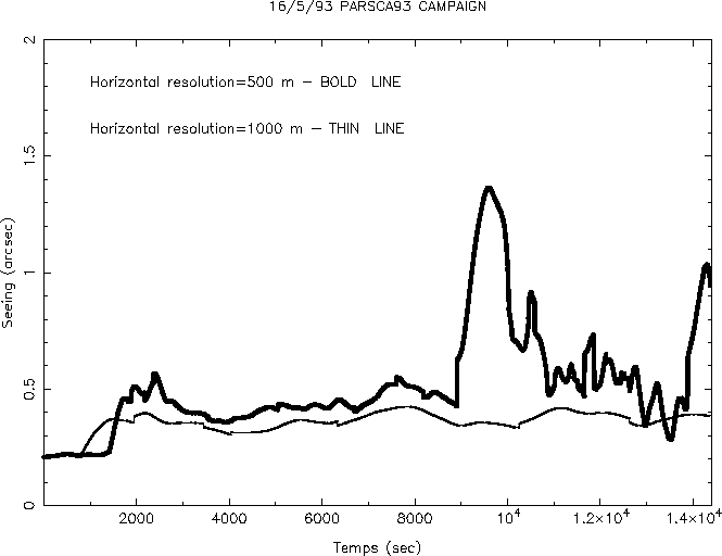 |
Figure 9:
Temporal seeing evolution during the 16/5/93 night
simulated by Meso-Nh using two
different horizontal resolutions:
1000 m |
In the following, typical model outputs related to the same 16/5/93 night of the PARSCA93 campaign show how the simulation results could be useful for flexible scheduling and site testing.
In Fig. 10 is reported an east-west ![]() (x, z) vertical section centered on the
Paranal and extending over 80 grid points
(40 km). In Figs. 11a-e are reported east-west
vertical sections, selected over the same 40 km, of different integrated parameters such as the
seeing
(x, z) vertical section centered on the
Paranal and extending over 80 grid points
(40 km). In Figs. 11a-e are reported east-west
vertical sections, selected over the same 40 km, of different integrated parameters such as the
seeing ![]() (Fig. 11a), the coherence
wavefront time
(Fig. 11a), the coherence
wavefront time ![]() (Fig. 11b), the isoplanatic angle
(Fig. 11b), the isoplanatic angle ![]() (Fig. 11c),
the scintillation rate
(Fig. 11c),
the scintillation rate ![]() (Fig. 11d) and the spatial coherence outer scale
(Fig. 11d) and the spatial coherence outer scale ![]() (Fig. 11e). In Figs. 12a-e
are displayed horizontal maps of the same parameters
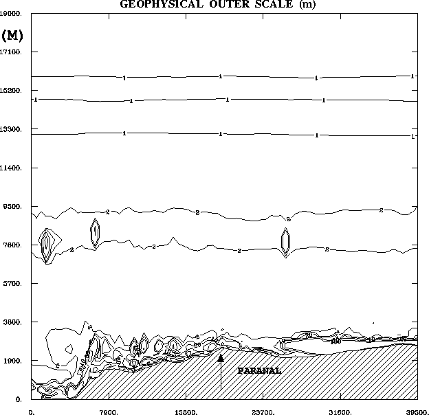
over the geographic surface displayed in (Fig. 1). One can observe the general coherence of
these model outputs. Above the chilean coast, on the west, we find large seeing values as seen in
Fig. 11a and Fig. 12a. This is caused by the presence of the steep slope
of this mountainous region producing the maximum rate of
turbulence. Weak seeing values characterize the central region around Paranal
and, finally, a more important seeing is found above higher mountains (> 3000 m) east of Paranal.
(Fig. 11e). In Figs. 12a-e
are displayed horizontal maps of the same parameters
over the geographic surface displayed in (Fig. 1). One can observe the general coherence of
these model outputs. Above the chilean coast, on the west, we find large seeing values as seen in
Fig. 11a and Fig. 12a. This is caused by the presence of the steep slope
of this mountainous region producing the maximum rate of
turbulence. Weak seeing values characterize the central region around Paranal
and, finally, a more important seeing is found above higher mountains (> 3000 m) east of Paranal.
 |
Figure 10:
16/5/93 night (PARSCA93 campaign). |
 |
Figure 11:
As Fig. 10.
East-west vertical sections of the integrated astronomic parameters coded
in Meso-Nh model. a) Seeing |
 |
![\begin{figure}
\includegraphics [height=18cm]{7850f12.eps}\end{figure}](/articles/aas/full/1999/10/ds7850/img84.gif) |
Figure 12:
Horizontal maps of the parameters showed in
Fig. 11 simulated on the same surface
as selected by the dashed lines in Fig. 1.
a) Seeing |
As the coherence wavefront time, the isoplanatic
angle (Fig. 11c, Fig. 12c) decreases over the coast. It maintains a more or
less constant value over the interior
region. One can observe that, in this case, the principal cause of a decreasing value of ![]() ,
from 0.3 to 0.1 arcsec, is the near ground turbulence present above the coast.
,
from 0.3 to 0.1 arcsec, is the near ground turbulence present above the coast.
The scintillation profile is strongly correlated to the seeing one
(Fig. 11a, Fig. 11c). A uniform value is observed
on the broad central region except for two little peaks at about 10 km to the east and west
of Paranal.
In Fig. 12c) one can remark a non realistic value (![]() > 1) of the scintillation rate above the chilean coast. This is due to the fact
that Eq. (24) is
obtained with the weak perturbation theory (Tatarski 1995), which is not verified in this area.
It is known that the scintillation rate is proportional to
the
> 1) of the scintillation rate above the chilean coast. This is due to the fact
that Eq. (24) is
obtained with the weak perturbation theory (Tatarski 1995), which is not verified in this area.
It is known that the scintillation rate is proportional to
the ![]()
![]()
![]() turbulence intensity only in the range
turbulence intensity only in the range ![]() < 0.3. For a greater
< 0.3. For a greater ![]()
![]() values the
values the
![]() reaches a saturated value of about 1. This means that any
reaches a saturated value of about 1. This means that any ![]() value greater of this
threshold is not significant.
Finally, one can observe in Fig. 11e and Fig. 12e that the outer scale
value greater of this
threshold is not significant.
Finally, one can observe in Fig. 11e and Fig. 12e that the outer scale ![]() increases
above the region of maximum
increases
above the region of maximum ![]() production, that is
over the coast, and at about 10 km at the east of the Paranal. One notes that the spatial outer scale
reaches very low values over the Paranal area (< 1 m).
In spite of the still open discussion in the astronomic community about the
production, that is
over the coast, and at about 10 km at the east of the Paranal. One notes that the spatial outer scale
reaches very low values over the Paranal area (< 1 m).
In spite of the still open discussion in the astronomic community about the ![]() estimation, these values
agree with those found by some authors (Nightingale et al. 1991; Fuchs 1995)
and they are supported
by the physical mechanism recently proposed (Coulman et al. 1995) to explain the optical turbulence
formation.
estimation, these values
agree with those found by some authors (Nightingale et al. 1991; Fuchs 1995)
and they are supported
by the physical mechanism recently proposed (Coulman et al. 1995) to explain the optical turbulence
formation.
 |
Figure 13:
Temporal evolution of the |
In the introduction of this paper we remembered that all the parameters affected
by the optical turbulence have a stochastic behavior. During a night, thin turbulent layers can
appear and disappear at different altitudes and times. Most simulation results presented
here are sampled at
an interval time of the order of
30 minutes or 1 hour. In order to fill this lack of information
in the temporal scale we modified the code to have a further output. It is now possible
to follow the temporal evolution of the ![]() profiles simulated at a precise point (x0,y0)
with a sampling time of about 2 minute. In Fig. 13 is reported an example of such a
temporal
profiles simulated at a precise point (x0,y0)
with a sampling time of about 2 minute. In Fig. 13 is reported an example of such a
temporal ![]() (h, t) output obtained over Roque de los Muchachos site in Canaries Isles. One can remark the presence of a strong turbulent layer at ground level,
persisting during the whole night
and a more variable turbulent structure at about 10 km. It is interesting to note that,
during the first 30 minutes, the model has not yet reached an orographic adaptation. This tool could make simpler a comparison
with Scidar measurements and it could be helpful to better define the forecast time.
(h, t) output obtained over Roque de los Muchachos site in Canaries Isles. One can remark the presence of a strong turbulent layer at ground level,
persisting during the whole night
and a more variable turbulent structure at about 10 km. It is interesting to note that,
during the first 30 minutes, the model has not yet reached an orographic adaptation. This tool could make simpler a comparison
with Scidar measurements and it could be helpful to better define the forecast time.
Copyright The European Southern Observatory (ESO)