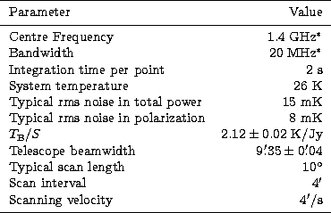
The method of observation is to scan each field along constant Galactic latitude as well as along constant Galactic longitude. Each field was measured at least twice. The telescope parameters relevant to the 1.4 GHz survey are listed in Table 1.
and/or a reduction of the bandwidth necessary. |
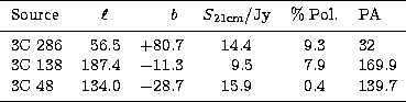
Daytime observations cause inacceptable distortions in both the total intensity and the polarization data due to contribution of solar emission to the far sidelobes of the telescope (Kalberla et al. 1980). Therefore all observations are carried out at nighttime, when additional ionospheric Faraday rotation effects are minimal and included by corrections inferred by observations of calibration sources. Calibration sources were 3C 286, 3C 138 and 3C 48, where 3C 286 served as the primary calibrator both in total intensity and polarization. The scale accuracy for total and polarized intensities is better than 5%. As seen from their coordinates, calibration sources have large angular separations on the sky, so that at least one of them is accessible at all times. Their polarization properties are listed in Table 2 and are taken from the list of Tabara & Inoue (1980).
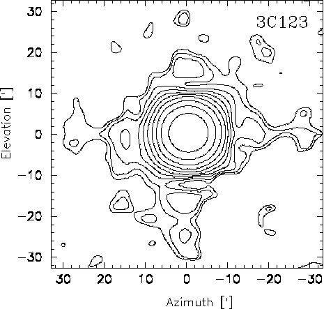 |
Figure:
1.4 GHz beam map covering an area of 1 |
In Fig. 1 we show a beam map at 1.4 GHz observed in the Az/El-system on 3C 123, which at that frequency shows no measurable variation with elevation. Compact background sources in the field of 3C 123 have been removed. The dynamic range exceeds 30 dB. The maximum of the first sidelobes, which are enhanced by the four subreflector support legs, are at a level of about -20 dB. The cross-polarization lobes of Stokes parameters U and Q are dominated by a main beam component, which varies with parallactic angle. A correction of that instrumental response is described below.
The first stage of the data reduction made use of the standard "Toolbox'' procedure (CONT2, von Kap-herr 1977) for continuum and polarization observations with the Effelsberg telescope. From the tabulated scans calibrated maps were computed for all the four data channels (two times I, U and Q) recorded. A linear baseline using data points at the end of each scan was subtracted from each channel. All later stages of the data reduction are based on the NOD2 program package (Haslam 1974). Spiky data were removed. Scanning effects were suppressed by using the method of unsharp masking developed by Sofue & Reich (1979). Finally, the two maps observed in orthogonal directions for each of the Stokes parameters have been added using the PLAIT program (Emerson & Gräve 1988), which reduces "scanning effects'' from individual distortions or by the baseline setting procedure in the case of an emission structure located at the edge of a map by appropriate weighted addition of the Fourier transforms of both maps. The polarization U and Q maps were corrected for instrumental polarization as described in Sect. 4 before combining the maps observed in orthogonal directions.
Copyright The European Southern Observatory (ESO)