The Westerbork Northern Sky Survey (WENSS) is being carried
out at 325 and 609 MHz (92 and 49 cm) with the Westerbork Synthesis Radio
Telescope (WSRT). At 325 MHz, WENSS covers the complete sky north of ![]() to a
limiting flux density of approximately 18 mJy (
to a
limiting flux density of approximately 18 mJy (![]() ). At 609 MHz, about a
quarter of this area, concentrated at high galactic latitudes, has been
surveyed to a limiting flux density of approximately 15 mJy (
). At 609 MHz, about a
quarter of this area, concentrated at high galactic latitudes, has been
surveyed to a limiting flux density of approximately 15 mJy (![]() ).
The systematic errors in flux density in WENSS were found to be
).
The systematic errors in flux density in WENSS were found to be
![]() (Rengelink et al. 1997). The
survey was conducted in mosaicing mode which is very efficient in terms of
observing time. In this mode, the telescope cycles through 80 evenly spaced
field centres, during each of a number of
(Rengelink et al. 1997). The
survey was conducted in mosaicing mode which is very efficient in terms of
observing time. In this mode, the telescope cycles through 80 evenly spaced
field centres, during each of a number of ![]() syntheses with different
spacings of array elements. The visibilities are sufficiently well sampled for
all 80 fields that it is possible to reconstruct the brightness distribution
in an area of the sky,
syntheses with different
spacings of array elements. The visibilities are sufficiently well sampled for
all 80 fields that it is possible to reconstruct the brightness distribution
in an area of the sky, ![]() 100 square degrees, which is many times larger
than the primary beam of the WSRT. Individual fields are referred to as
mosaics, and have a resolution (FWHM of the restoring beam) of
100 square degrees, which is many times larger
than the primary beam of the WSRT. Individual fields are referred to as
mosaics, and have a resolution (FWHM of the restoring beam) of ![]() cosec
cosec ![]() at 325 MHz and
at 325 MHz and ![]() cosec
cosec ![]() at
609 MHz. From the combined mosaics, maps are made with a uniform sensitivity and
regular size, which are called frames. The 325 MHz frames are
at
609 MHz. From the combined mosaics, maps are made with a uniform sensitivity and
regular size, which are called frames. The 325 MHz frames are ![]() in size and positioned on a regular
in size and positioned on a regular ![]() grid over the sky, which coincides with the position grid of the new Palomar
Observatory Sky Survey (POSS II,
Reid et al. 1991) plates.
A detailed description of WENSS is given by
Rengelink et al. (1997)
grid over the sky, which coincides with the position grid of the new Palomar
Observatory Sky Survey (POSS II,
Reid et al. 1991) plates.
A detailed description of WENSS is given by
Rengelink et al. (1997)
A deep low frequency radio survey such as WENSS is crucial for selecting a sample of faint GPS sources. It is the inverted spectrum at low frequencies which distinguishes them from other types of radio sources. Figure 1 shows the major large-sky radio surveys in the northern sky with theoretical spectra of homogeneous synchrotron self absorbed radio sources (e.g. Moffet 1975) superimposed, which have spectral peak frequencies of 1 GHz. Samples of GPS sources can be constructed using WENSS flux density measurements in the optically thick part of their spectra which are ten times fainter than samples selected using the Texas Survey (Douglas 1996).
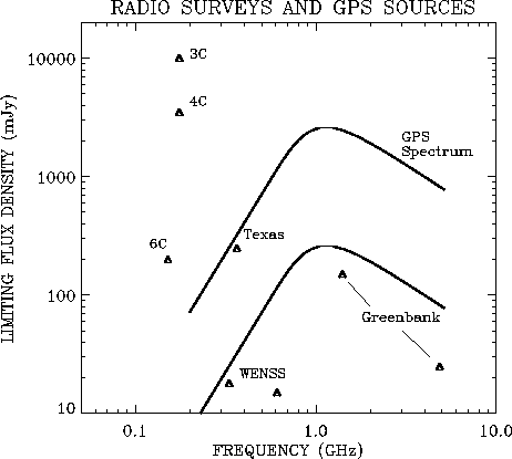 |
Figure 1: Overview of the major radio surveys in the northern sky: the Greenbank Surveys (Condon & Broderick 1985; Gregory & Condon 1991), the Texas Survey (Douglas et al. 1996), and the Cambridge 3C, 4C, and 6C surveys. The curves represent the spectra of a homogeneous synchrotron self absorbed radio source, with a peak frequency of 1 GHz and peak flux density of 300 mJy (lower curve) and 3000 mJy (upper curve). Samples of GPS sources can be constructed using WENSS flux density measurements in the optically thick part of their spectra which are more than an order of magnitude fainter than samples selected using the Texas Survey |
When we selected our sample, only a small part of the WENSS
region had been observed and the data reduced to the point of providing
source lists. The 325 MHz WENSS data used to select GPS sources are from two
regions of the sky; one at ![]() and
and ![]() , which is called the mini-survey region
(Rengelink et al. 1997),
and the other at
, which is called the mini-survey region
(Rengelink et al. 1997),
and the other at ![]() and
and ![]() ,where
,where ![]() is right ascension and
is right ascension and ![]() is declination.
These were the first two regions observed, reduced and analysed for WENSS.
The mini-survey region,
which is roughly centered on the North Ecliptic Pole, was chosen as the first
area for analysis because it coincides with the NEP-VLA survey at 1.5 GHz
(Kollgaard et al. 1994), the deep 7C North Ecliptic Cap survey
(Lacy et al. 1995;
Visser et al. 1995), the deepest part of the ROSAT All Sky survey
(Bower et al. 1996) and the IRAS survey
(Hacking & Houck 1987). The high declination of the two regions is very convenient for
VLBI experiments, because their locations are circumpolar for almost all the
major EVN
and VLBA radio telescopes. At the time of selection WENSS 609 MHz data
was available for only about one third of the mini-survey region.
The regions for which both 325 and 609 MHz source lists were available cover 119
square degrees of the sky. The regions for which only 325 MHz data were
available cover 216 square degrees in the mini-survey region and 306 square
degrees in the other region.
is declination.
These were the first two regions observed, reduced and analysed for WENSS.
The mini-survey region,
which is roughly centered on the North Ecliptic Pole, was chosen as the first
area for analysis because it coincides with the NEP-VLA survey at 1.5 GHz
(Kollgaard et al. 1994), the deep 7C North Ecliptic Cap survey
(Lacy et al. 1995;
Visser et al. 1995), the deepest part of the ROSAT All Sky survey
(Bower et al. 1996) and the IRAS survey
(Hacking & Houck 1987). The high declination of the two regions is very convenient for
VLBI experiments, because their locations are circumpolar for almost all the
major EVN
and VLBA radio telescopes. At the time of selection WENSS 609 MHz data
was available for only about one third of the mini-survey region.
The regions for which both 325 and 609 MHz source lists were available cover 119
square degrees of the sky. The regions for which only 325 MHz data were
available cover 216 square degrees in the mini-survey region and 306 square
degrees in the other region.
These source lists were correlated with those from the Greenbank 5 GHz (6 cm)
survey
(Gregory & Condon 1991;
Gregory et al. 1996), which has a limiting
flux density of 25 mJy (![]() ). For the faintest sources the new Greenbank source list
(Gregory et al. 1996) was used, which is based on more data.
Candidate GPS sources were selected on the basis of a
positive spectral index
). For the faintest sources the new Greenbank source list
(Gregory et al. 1996) was used, which is based on more data.
Candidate GPS sources were selected on the basis of a
positive spectral index ![]() between 325 MHz and 5 GHz, where the spectral
index is defined by
between 325 MHz and 5 GHz, where the spectral
index is defined by ![]() . If 609 MHz data was also available,
an "inverted'' spectrum between 325 MHz and 609 MHz was used as the selection
criterion. This in fact increased the sensitivity of the selection process to
GPS sources with low peak frequencies (< 1 GHz). Note that in general for a
GPS source, the 325 - 609 MHz spectral index
will be more positive than the
325 - 5000 MHz spectral index for a spectral peak in
the 1 GHz range. Hence,
using the 325 - 609 MHz selection criterion will
not miss any GPS sources which
would have been found using the 325 - 5000 MHz
selection criterion, it will only
add extra sources with lower peak frequencies.
. If 609 MHz data was also available,
an "inverted'' spectrum between 325 MHz and 609 MHz was used as the selection
criterion. This in fact increased the sensitivity of the selection process to
GPS sources with low peak frequencies (< 1 GHz). Note that in general for a
GPS source, the 325 - 609 MHz spectral index
will be more positive than the
325 - 5000 MHz spectral index for a spectral peak in
the 1 GHz range. Hence,
using the 325 - 609 MHz selection criterion will
not miss any GPS sources which
would have been found using the 325 - 5000 MHz
selection criterion, it will only
add extra sources with lower peak frequencies.
In total, 117 inverted spectrum sources were selected; 37 using the 325 - 609 MHz selection and 82 using the 325 - 5000 MHz selection. They are listed in Table 1. Columns 1, and 2 give the name, right ascension and declination (B1950) (obtained from the VLA observations), Cols. 3, 4 and 5 the 325 MHz, 609 MHz and 5 GHz flux densities, and Cols. 6 and 7 give the 325 - 609 MHz and 325 - 5000 MHz spectral indices. The uncertainties in the 325 - 5000 MHz spectral indices range from 0.03 to 0.05 (for the faintest objects), and the uncertainties in the 325 - 609 MHz spectral index range from 0.10 to 0.40.
An apparently inverted or peaked spectrum could be caused by variability at any or all of the selection frequencies, due to the fact that the 325, 609 and 5000 MHz surveys were observed at different epochs. The 5 GHz Greenbank survey was made in 1987, while the 325 MHz and 609 MHz data were taken in 1993. To select the genuine GPS sources, additional quasi-simultaneous observations at other frequencies are required to eliminate flat spectrum, variable radio sources. Furthermore, high frequency data is needed to confirm their turnover, and measure the (steep) spectrum in the optically thin part of their spectra. Therefore VLA observations were taken at 8.4 and 15 GHz, and WSRT observations at 1.4 and 5 GHz. Later, after the selection process, data at 1.4 GHz from the NRAO VLA Sky Survey (NVSS, Condon et al. 1996) became available and were used to supplement our spectra.
The WSRT was used to observe the candidate GPS sources at 1.4 and 5 GHz. The
1.4 GHz observations were performed on 20 February and 10 March 1994 using
8 bands of 5 MHz between 1377.5 and 1423.5 MHz, providing a
total bandwidth of
40 MHz. The sources were all observed for about 100 seconds
at two to three
different hour angles. This resulted in a
noise level of typically 1 mJy/beam
and a resolution of ![]() .
The results are shown in
Col. 8 of Table 1.
.
The results are shown in
Col. 8 of Table 1.
In order to improve the 5 GHz Greenbank flux density measurements, observations
were carried out with the WSRT at 4.87 GHz on May 15 1994 using a bandwidth
of 80 MHz, at a time when the WSRT was participating a VLBI session. Unfortunately only
three telescopes were equipped with 5 GHz receivers. Only sources between 4
and 8 hours right ascension were observed, and the uncertainty in the
measured flux densities is large (![]() %). The resulting flux densities
are listed in Col. 13 in Table 1.
%). The resulting flux densities
are listed in Col. 13 in Table 1.
The candidate GPS sources were observed with the VLA in B-configuration at 8.4
and 15 GHz on 23 July 1994. At both frequencies, the objects were observed in
a standard way using a bandwidth of ![]() MHz.
The phases
were calibrated using standard nearby VLA phase calibrators. Total integration
times were typically 100 seconds at both frequencies, resulting in noise levels
of 0.2 and 1.0 mJy/beam respectively.
Systematic errors in flux density of VLA observations
at these frequencies are typically about
MHz.
The phases
were calibrated using standard nearby VLA phase calibrators. Total integration
times were typically 100 seconds at both frequencies, resulting in noise levels
of 0.2 and 1.0 mJy/beam respectively.
Systematic errors in flux density of VLA observations
at these frequencies are typically about ![]() (e.g.
Carilli et al. 1991).
The data were reduced using AIPS in a standard manner,
including
several iterations of phase self-calibration. The synthesized beams
have half widths of
(e.g.
Carilli et al. 1991).
The data were reduced using AIPS in a standard manner,
including
several iterations of phase self-calibration. The synthesized beams
have half widths of ![]() and
and ![]() at 8.4 and 15
GHz respectively. Several candidate GPS sources had already been observed at
8.4 GHz on February 26 1994 and April 3 1994
during the Cosmic Lens All Sky Survey (CLASS) program (e.g.
Myers et al. 1995);
these were not re-observed by us at 8.4 GHz. The CLASS 8.4 GHz
observations were made using the VLA in A configuration in a standard way, also
with a bandwidth of
at 8.4 and 15
GHz respectively. Several candidate GPS sources had already been observed at
8.4 GHz on February 26 1994 and April 3 1994
during the Cosmic Lens All Sky Survey (CLASS) program (e.g.
Myers et al. 1995);
these were not re-observed by us at 8.4 GHz. The CLASS 8.4 GHz
observations were made using the VLA in A configuration in a standard way, also
with a bandwidth of ![]() MHz and an average integration time of 30
seconds. The resolution of the CLASS observations was
MHz and an average integration time of 30
seconds. The resolution of the CLASS observations was ![]() , and the
noise level
, and the
noise level ![]() mJy/beam.
mJy/beam.
The results of the VLA observations are listed in Cols. 9 and 10 in Table 1. All of the sources were unresolved, except for B1608+6540, which was found to be a quadruple gravitational lens (Snellen et al. 1995b; Myers et al. 1995; Fassnacht et al. 1996)
Observations for the 1.4 GHz NRAO VLA Sky Survey (NVSS,
Condon et al. 1996)
began in September 1993 and are planned to cover the sky north of
declination ![]() (82% of the celestial sphere).
Data in our regions of interest
were taken on 1 November 1993 for the region
(82% of the celestial sphere).
Data in our regions of interest
were taken on 1 November 1993 for the region ![]() , and on 2
April 1995 for the region between
, and on 2
April 1995 for the region between ![]() . The noise level in
an image is typically 0.5 mJy/beam and the resolution is 45''.
. The noise level in
an image is typically 0.5 mJy/beam and the resolution is 45''.
The final sample of genuine GPS sources, as selected in Sect. 2.4, was observed with MERLIN at 5 GHz on 15 and 16 May 1995 during our global VLBI measurements. The sources were observed in three to four "snapshots'' of 13 minutes each, resulting in a noise level of typically 0.3 mJy/beam, and a resolution of 0.04''. All the sources were unresolved. The results are listed in Col. 14 of Table 1. Note that these observations were obtained after, and therefore not used for, the final selection.
The genuine GPS sources were selected using the 325 MHz and, if available, the 609 MHz WENSS data, 1.4 GHz WSRT data, 5 GHz Greenbank data and 8.4 and 15 GHz VLA data. The WSRT 5 GHz data were not used for selection because they were only available for a part of the sample. The NVSS data was not used for selection, being not available at the time of source selection. However, both the 5 GHz WSRT and 1.4 GHz NVSS data were used for variability studies (see Sect. 3).
The selection criteria were as follows:
The resulting sample of 47 sources is listed in Table 2. One of the sources, B1807+5959, did not obey the criterion of decreasing flux density above the peak frequency, because the 5 GHz Greenbank flux density flux point is too low. However it was kept in the sample because the fall off in flux density at both low and high frequencies suggests that the low flux density point at 5 GHz is due to the different epoch of the Greenbank observations. Additional observations showed this to be true.
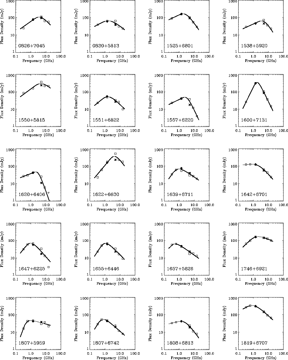
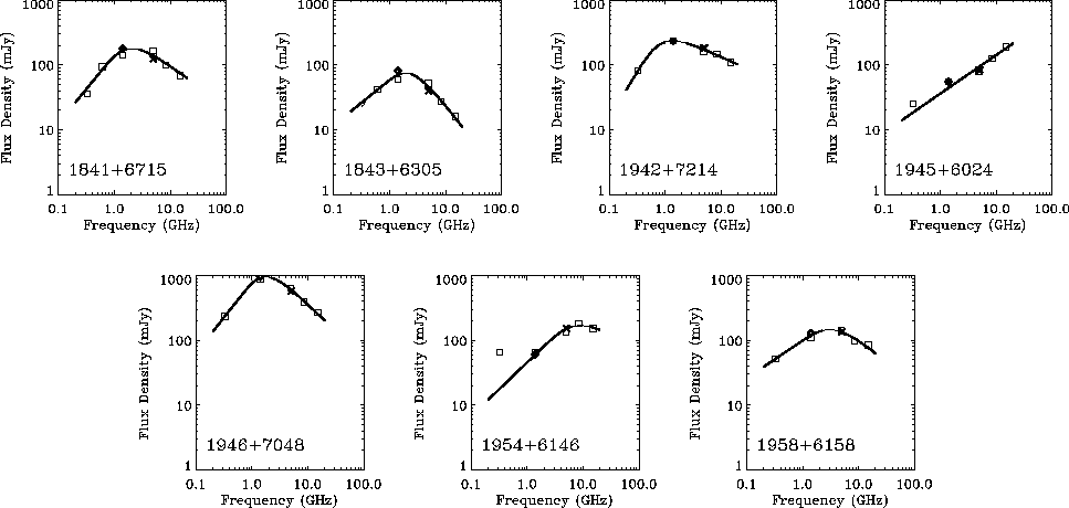
The spectra of the selected GPS sources were fitted with the following
function
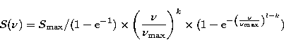 |
(1) |
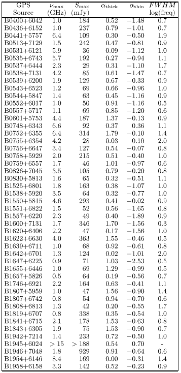
Figure 2 shows that three of the 47 sources initially selected probably do not have genuine GPS spectra, namely B0531+6121, B0748+6343 and B0755+6354. In these cases differences between MERLIN, Greenbank and WSRT 5 GHz flux density measurements suggest that the measured spectra are contaminated by flux density variability and it is not clear whether the spectra do indeed exhibit a peak. Although we have included them in the sample, we omit them from the analysis below. Note that no sign of a turnover is seen in B1945+6024, and that there are some sources in the sample which do not have a "clean'' peaked spectrum, like B1954+6146 and B0535+6743. To obtain a better determination of the spectral peak of B1954+6146, the 325 MHz flux density data point is not used to fit the spectrum.
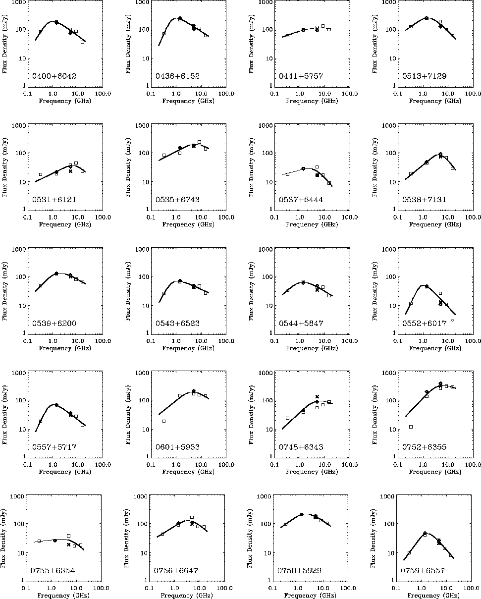 |
Figure 2: Radio spectra of individual sources. Crosses indicate MERLIN data, diamonds indicate at 1.4 GHz NVSS data and at 5 GHz WSRT data |
Copyright The European Southern Observatory (ESO)