Stray radiation due to ground emission in the GEM experiment was initially
recognized to attain hazardous levels during test operations at the Brazilian site
(W
![]() )
when only the rim-halo
protection had been installed. Figure 2 shows a sky map from a sample batch
containing 123.92 hours of data taken during this testing period at 1465MHz, where the
horizontal striping shows clear evidence of a variable component of sidelobe
contamination due to ground emission for the zenith-centered circularly scanning
motion of the antenna. The map was prepared according to the same data reduction process
that will be outlined in Sect. 5.1 and included custom cuts of
)
when only the rim-halo
protection had been installed. Figure 2 shows a sky map from a sample batch
containing 123.92 hours of data taken during this testing period at 1465MHz, where the
horizontal striping shows clear evidence of a variable component of sidelobe
contamination due to ground emission for the zenith-centered circularly scanning
motion of the antenna. The map was prepared according to the same data reduction process
that will be outlined in Sect. 5.1 and included custom cuts of
![]() from axis for
the Sun, of
from axis for
the Sun, of
![]() for the Moon and eventual excision of RFI signals. The
relative calibration of the map was, however, not subjected to an adopted baseline subtraction
technique which filters out low frequency noise. Instead, we assumed that any
continuous set of data between successive firings of the calibrating noise source
diode (comprising about 70% of a full scan or, equivalently, 35% of the
angular extent of a great circle in the sky) would contain, at least, one pointing
direction towards which the sky would appear uniformly cold across the entire
declination band being mapped. This assumption is realistically incorrect, but as
Fig. 3 shows, it is nevertheless useful to portray a reasonable outline of Galactic
features albeit an unnaturally flattened temperature distribution and some residual
stray radiation of Solar and artificial origin. The latter was absent during the test
runs only to emerge later with a 100% duty cycle and in the direction of a near
urban area.
for the Moon and eventual excision of RFI signals. The
relative calibration of the map was, however, not subjected to an adopted baseline subtraction
technique which filters out low frequency noise. Instead, we assumed that any
continuous set of data between successive firings of the calibrating noise source
diode (comprising about 70% of a full scan or, equivalently, 35% of the
angular extent of a great circle in the sky) would contain, at least, one pointing
direction towards which the sky would appear uniformly cold across the entire
declination band being mapped. This assumption is realistically incorrect, but as
Fig. 3 shows, it is nevertheless useful to portray a reasonable outline of Galactic
features albeit an unnaturally flattened temperature distribution and some residual
stray radiation of Solar and artificial origin. The latter was absent during the test
runs only to emerge later with a 100% duty cycle and in the direction of a near
urban area.
| |
Figure 3: A GEM map at 1465MHz of the same sky region as that in Fig. 2 (same baseline assumption and pixel size), but using data obtained after the wire mesh screen had been added to the shielding configuration of the antenna. The antenna temperature ranges also over 1.5þK above the lowest temperature, but the contour levels are spaced more tightly (60þmK). Marked locations denote the sky directions of the 6 test measurements discussed in Sect. 5 |
Figure 3 is a map of the same declination band as that of Fig. 2 after a fence of wire mesh had been built around the rotating antenna. A total of 222.57 hours of data from an optimally-stable receiver were used in the preparation of this map. The azimuth-dependent contamination from the ground has been largely removed and we can estimate its level by subtracting representative azimuth scans from the two maps as described below. No absolute calibration of the baseline was attempted for either of these maps, as it is not relevant for determining differential measurements. This approach will enable us to refine the model used in Sect. 5 for predicting a best estimate of the level of the azimuth-independent component of ground contamination in the survey. The locations marked in the map of Fig. 3 correspond to the chosen set of sky directions, grouped pair-wise, for obtaining the differential sky measurements. They avoid the proximity of the Galactic Plane in order to diminish the chance of scale error corrections.
 |
Figure 4: Antenna temperature profiles obtained before and after the construction of the fence and sampled along the scanning direction in regions of relatively low sky contrast |
The variable or azimuth-dependent component of ground contamination can be
estimated by adequate
comparison of the azimuth antenna temperature profiles before and after the
introduction of the fence. Figure 4 shows two such sets of profiles. They
were obtained from single time-ordered series of scans covering the same regions
of the sky and they sample the sky in 122 alt-azimuth circular bins spanning
approximately half-a-beamwidth across. This binning criteria is a basic precept
for the relative calibration of the survey and it will not be discussed further in the
present context. A full treatment of this calibration technique can be found in
Tello (1997) and will be included in the publication of the survey. At this point we
just mention that the series of scans were chosen for complying with highly stable
receiver performance and relatively high Galactic latitude. This combination
favours sky profiles of low emission contrast for easier identification of the
ground contribution to the antenna temperature. The circular arrangement of the
sampled bins has been schematically superimposed against the observed sky in
Figs. 5a,b. Thus the difference between the antenna temperature profiles in
Fig. 4 is a good approximation (see Fig. 6) of the ground contamination in the
absence of the fence. It can be seen to be made up of a variable component with a
mean amplitude of
![]() þK above the level of a uniform
azimuth-independent component. The two components result from the
convolution of the antenna beam pattern over the ground temperature
distribution, whose spatial extent in the vertical direction is limited by the line of
the horizon also depicted in Fig. 6.
þK above the level of a uniform
azimuth-independent component. The two components result from the
convolution of the antenna beam pattern over the ground temperature
distribution, whose spatial extent in the vertical direction is limited by the line of
the horizon also depicted in Fig. 6.
![\begin{figure}
\includegraphics[width=18cm,clip]{H1976F5.eps}\end{figure}](/articles/aas/full/2000/15/h1976/img38.gif) |
Figure 5:
Maps of the sky regions revealed by the circularly scanning technique of
the GEM experiment at 1465MHz, a) before and b) after the construction of the fence,
and the distribution of the alt-azimuth sky bins used in the sampling of the
signal displayed in the antenna temperature profiles of Figs. 4a,b. Map a)
consumed 2.29þhours of observational time and Map b) 2.18þhours. Both
maps are given at a
|
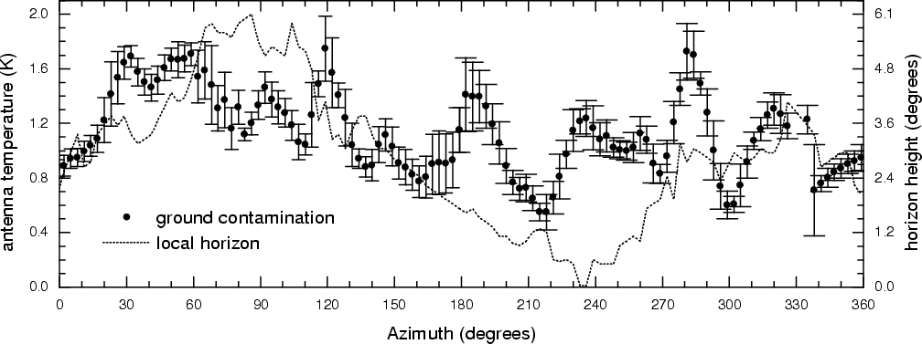 |
Figure 6: The level of ground contamination in the absence of the fence deduced from the difference in antenna temperature between the profiles of Fig. 4. The dotted line depicts the horizon profile at the observational site |
 |
Figure 7:
Diagram representations of the backfire power patterns at a) 408MHz
and b) 1465MHz in a coordinate reference frame centered on the transmitter.
Three concentric circles have been superimposed on the diagrams to
illustrate the opening angles of the ground shields: the boundary of the dish
itself at
|
In the presence of the fence, we can estimate the azimuth-independent component of ground contamination by convolving the antenna beam pattern with an uniform field of radiation confined to the solid angle that the fence fills in at the prime focus of the parabolic dish. In this case, the beam pattern is the modified feed response which due to the presence of the shields gives rise to spillover and diffraction sidelobes. This is the subject we deal with in the next two sections before we assess the reality of the observations.
Copyright The European Southern Observatory (ESO)