Two different sort of initialization data have been used: radiosoundings and analyses. In order to make atmospheric forecasts at synoptic scales, a customer has a finite number of observation data available, moreover not uniformly distributed. There are regions, such as ocean, where the observation density is extremely low. Operational meteorological centers can provide the analyses as a result of a sophisticated interpolation of the observations (Annexe 1) to fill the missing information. Then the initial information (observations) becomes spatially uniform but it remains discrete in time.
We used for this study the Antofagasta station (70.43 W, 23.43 S) radiosounding profiles and ECMWF analyses computed to the nearest grid point (70.31 W, 23.62 S) to the Antofagasta station provided for all the synoptic hours (00:00 U.T., 06:00 U.T., 12:00 U.T. and 18:00 U.T.). The Antofagasta station provides observations only once a day (12:00 U.T.), instead of twice, as usual in the standard procedure (12:00 U.T. and 00:00 U.T.). This is a problem for the initialization phase of the Meso-Nh model. 12:00 U.T. is about two hours after the end of the night as can be seen in Fig. 2. Throughout the whole campaign, the Scidar observations took place in the first part of the night, between 00:00 U.T. and 05:30 U.T., corresponding to the only double star available. This means that we do not have radiosoundings taken when the Scidar was operated.
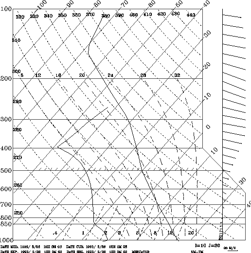 |
Figure 4: Analysis emagram - 26 May 1993 at 12:00 U.T. - Same as Fig. 3. The stratospheric warming is noticed. The thermic inversion at ground levels (under 750 hPa) is lost |
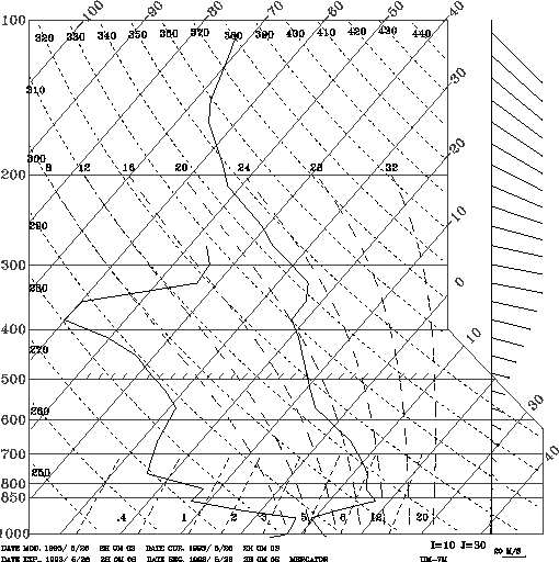 |
Figure 5: Initialization Emagram - 26 May 1993 (same presentation as Fig. 3). The radiosounding temperature profile (1000 hPa - 150 hPa) is corrected at high levels (over 150 hPa) by the analysis data. In the low atmosphere levels (1000 hPa - 750 hPa) the analysis wind direction and amplitude are used |
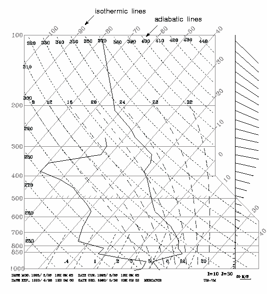
The quality of radiosoundings and analysis data is an important aspect of the simulation procedure because initial conditions of low quality may produce erroneous simulation results. To estimate the differences between the radiosoundings and the ECMWF analysis temperature profiles we show the emagrams related to the two cases provided by Meso-Nh. An emagram is a thermodynamical diagram used to describe the atmospheric state. As an example, in Fig. 3 we show, for the 26 May 1993, the radiosoundings emagram at 12:00 U.T. and in Fig. 4 the analysis emagrams at the same hour. The pressure is plotted in ordinates. The isotherms are inclined at 45 degrees and have a linear scale and the adiabats are represented by dashed, bent, transverse lines. The temperature profile is represented by the right side curve. These figures represent just two samples taken from our data, but after a complete analysis of all the campaign emagrams, we can make the following general remarks: the radiosoundings temperature profile resolution is higher than that provided by the meteorological analysis. Moreover, the thermal inversion of low layers (below 850 hPa) is not detected in the analysis data whereas it appears in the radiosoundings. The temperature profiles given by radiosoundings in the higher layers do not reproduce the typical thermal inversion above the tropopause (at around 150 hPa). A possible explanation of the low vertical resolution of the analysis data is that they are calculated at only 15 levels, introducing an important averaging effect.
The analysis temperature profiles have a low vertical resolution provided by a spatial (vertical) and temporal interpolation process. The temporal resolution is limited by the fact that observations are taken only once a day. The intensity and wind directions, taken from radiosoundings and analyses at 12:00 U.T. are better correlated. Few discrepancies are found especially at low atmospheric levels.
How do we choose the best initialization criterion? It is not possible to use simple radiosounding or analysis
temperature profiles for the reasons just presented.
The model must be fed by wind and
temperature profiles which best represent the atmospheric behavior at this latitude,
in term of thermodynamic equilibrium. For this reason, considering
the low resolution of the analysis data, we thought that the best
solution was to mix the radiosoundings and the analyses:
we used the radiosounding temperature profile between
![]() and
and ![]() and the analysis above
and the analysis above ![]() .
In Fig. 5 we show, as an example, the result of such a mixing between
the radiosounding and analysis shown in Fig. 3 and Fig. 4. In this way,
we hope to preserve the best vertical resolution. Knowing that the orographic effects are particularly sensitive
to the wind near the ground, we used in the low part of the atmosphere (
.
In Fig. 5 we show, as an example, the result of such a mixing between
the radiosounding and analysis shown in Fig. 3 and Fig. 4. In this way,
we hope to preserve the best vertical resolution. Knowing that the orographic effects are particularly sensitive
to the wind near the ground, we used in the low part of the atmosphere (![]() ),
the analysis wind direction and intensity at
),
the analysis wind direction and intensity at ![]() U.T., that is the nearest
temporal wind data in this region of the atmosphere.
U.T., that is the nearest
temporal wind data in this region of the atmosphere.
After analyzing the whole campaign, an unrealistic radiosounding
temperature profile caused the generation of numerical instabilities on two occasions
and simulations could not be terminated.
We show here an example of the outputs provided by the model in which a numerical
instability is detected. Figure 6 shows the seeing time evolution over the Paranal mountain for the 13 May 1993 night. After 200 s, the model generates a dynamic instability
caused by the presence of a quasi-null gradient of potential temperature
(![]()
![]() 0) at about 10.5 km with a 2 km
depth as seen in Fig. 7 (absolute temperature parallel to the adiabats).
The presence of a strong wind gradient, coupled with a low potential temperature gradient induces a Richardson number Ri < 0.25 at this altitude, as seen in Fig. 8.
Figure 9 shows the
0) at about 10.5 km with a 2 km
depth as seen in Fig. 7 (absolute temperature parallel to the adiabats).
The presence of a strong wind gradient, coupled with a low potential temperature gradient induces a Richardson number Ri < 0.25 at this altitude, as seen in Fig. 8.
Figure 9 shows the ![]() profile generated by the model along with the profile measured by Scidar on the same night. Evidently, a wrong radiosounding can trigger numerical instability.
profile generated by the model along with the profile measured by Scidar on the same night. Evidently, a wrong radiosounding can trigger numerical instability.
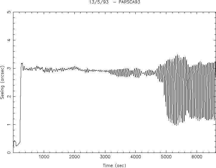 |
Figure 6: Seeing temporal evolution over 4 hours simulations time above Paranal mountain during the 13 May 1993 night. A numerical instability appears due to unrealistic initial conditions |
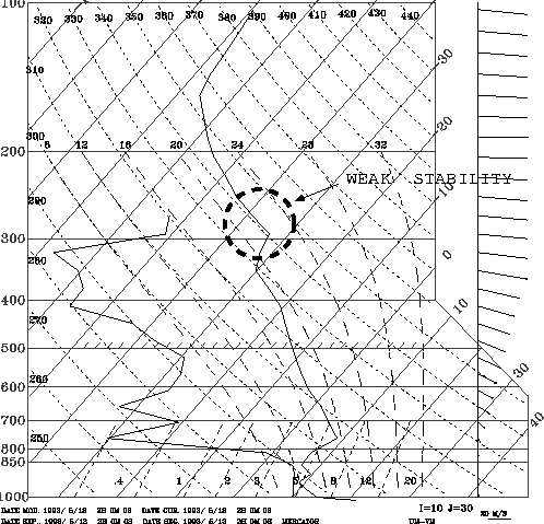 |
Figure 7: Initialization emegram - 13 May 1993 (same as Fig. 3). A large region of low static stability is present at 300 hPa about |
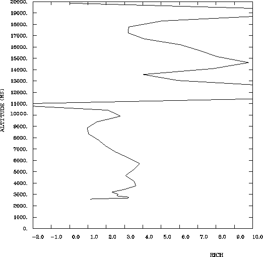 |
Figure 8: Richardson number profile above Paranal during the 13 May 1993. A dynamic instability is present around 11 km |
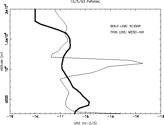 |
Figure 9:
|
Copyright The European Southern Observatory (ESO)